
| HRLPC Home | Distance | Maintained By | Parking | Trail Walk | Historical Info |
|---|---|---|---|---|---|
| Trail Restrictions | Blaze Markings | Trail Benches | Trail Photos |
Maintained by: The Hockanum River Linear Park Committee (HRLPC)
Parking at the beginning of the trail:
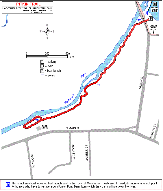
The Pitkin Trail is located downstream from Union Street and the Union Pond Dam. Parking is located on the east side
of Union Street next to the Union Pond Dam.
The trail walk:
(Note that the HRLPC favors locating the trail as close to the river as possible when laying out and clearing trails.)
Spectacular views of the 60 acre pond, and the dam with water spilling over it, are seen from the parking lot here.
More views of the dam can be seen from the base of the steps down under the Union Street Bridge. The trailhead, marked
with a green and white "Hockanum River Hiking Trail" sign, is across the street. The hiking trail proceeds downstream for 0.4
mile and returns over the same course.
This trail is one of the most scenic, hilly and tranquil of all those along the Hockanum River. The path winds
through a lush green forest valley totally away from all intrusions of traffic noise.
The trail immediately goes down a flight of steps to a sandstone ledge close above the river, with great views of the
bridge and dam upstream and of the waterway off to the left. Orange blazes guide the hiker as the path wanders up and down
slopes, through wetlands and over 2 brooks on small footbridges, past a bench with a spectacular view upstream, close to
and high above the Hockanum, for very scenic vistas everywhere. The virgin forest setting is enchanting. Then the path
follows behind a few homes, and then close behind the Minimart off North Main Street.
The trail ends here for now, until easements can be secured to extend the walkway out to North Main Street and further
beyond.
Fauna along this trail includes white tail deer, rabbits, wild turkeys and woodchucks. Flora includes mostly forest
trees: oak, maple, white ash and black cherry. Wild flowers are scarce due to the dense tree canopy overhead. There is a
lush growth of watercress in the marsh next to bridge number 1.
Historical Information:
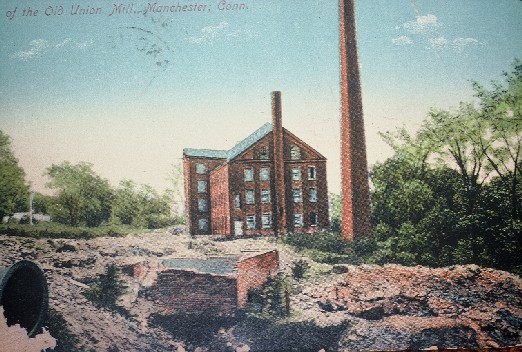
There are remnants of bricks and sandstone blocks along the path, the only remains of a once-flourishing cotton mill
erected by the Pitkin family in 1794. This cotton mill, the first in Connecticut, was built on the river here by Elisha
Pitkin (1733-1819), with waterpower from the Union Pond Dam. This Pitkin Cotton Mill was deeded over to his 3 sons,
Samuel, Edward and Joseph.
Later the Pitkin Mill was enlarged to become the Union Manufacturing Company and was the largest sandstone building in
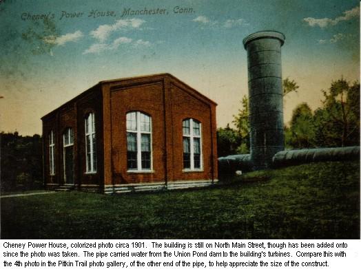
the state in 1823. The Cheney Brothers purchased the mill in 1900 and added a hydroelectric plant on North Main Street,
with waterpower from the Union Pond Dam to furnish electricity to their silk complex off Hartford Road. The Union
Manufacturing Company sandstone blocks were used to build the Cheney RIbbon Mill.
Elisha Pitkin died in 1819, his son Samuel in 1839, and Samuel's son Samuel in 1845. They are buried in the Pitkin
plot in the East Hartford Center Cemetery. (Manchester was part of East Hartford until 1823.)
The Pitkin Trail is unique historically as well with the existence of segments of a large steel pipe, over 6 feet in
diameter, which carried water from the Union Pond Dam down to the brick Cheney Brothers power plant on North Main Street.
Old timers recall seeing water spraying and freezing out of rusted holes in the pipe in the early 1900s when it was in use.
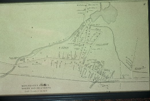
Following are historical images of the Union Pond and Pitkin Mill complex. Click on any image to bring up a
larger version of it.
|
|
|
|---|