
| HRLPC Home | Distance | Maintained By | Parking | Trail Walk | Trail Restrictions |
|---|---|---|---|---|---|
| Blaze Markings | Trail Benches | Trail Photos |
Maintained by: The Hockanum River Linear Park Committee (HRLPC)
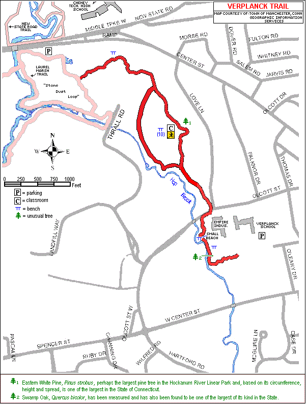
Parking at the beginning of the trail:
Parking is at the Laurel Marsh (stone dust) Parking Lot on the south side of Routes 6 & 44 across from Cheney
Technical School or in the Verplanck School Parking Lot next to the school.
The trail walk:
(Note that the HRLPC favors locating the trail as close to the river as possible when laying out and clearing trails.)
Beginning at the Laurel Marsh parking lot (Stone Dust lot), the course of the Verplanck Trail follows the Stone Dust
Path to the left from the parking lot, then curves around to the right and left, and makes a sharp left at a sign saying
"Olcott Street." It next follows a wood chip path through the beautiful mature forest, over several boardwalks, and curves
around the water treatment plant. It then goes through a wetland over multiple boardwalks and over a berm; followed by yet
more boardwalks and deep woodland of pines and hardwoods.
After a few gentle turns, the trail passes an outdoor classroom of wooden benches used by Verplanck Elementary School
class hikes on the right. There are a few very large white pine trees in this area. The trail curves around to the right
and left, passing a radio transmission tower on the left and the Leber Baseball Field on the right.
After crossing the dirt road to the field, the path follows a woodland course again, with Hop Brook about 50 feet or
so off to the right. Eventually the trail comes out at the corner of Love Lane and Olcott Street. Verplanck Elementary
School is across Olcott Street and up the hill to the left.
There is an additional section of the Verplanck Trail across Olcott Street just to the right of Empire Industries in
the driveway of the small CL&P substation and Cell Tower. This trail extension follows upstream close to the very scenic
Hop Brook and then curves to the left behind Empire Industries, through more woods, and up a set of steps to the rear
playground of the Verplanck School.
The Verplanck School classes use this trail for nature study hikes and outdoor classroom on a regular basis in spring
and fall. Various classes practice their snowshoe exercises and wildlife tracking activities in winter.
Historical Information:
The Verplanck Trail is, of course, named after the Verplanck School, which is near its terminus behind
Empire Industries. The School, however, is named after Fred Ayer Verplanck, who is one of the most remarkable
men to have lived in Manchester, who arrived in Manchester in a horse-and-buggy, became principal of its first
high school, then became superintendent of the South Manchester Public Schools and later of all Manchester
schools after they were consolidated; a post which he held until his retirement in 1935. In all Mr. Verplanck
spent 53 years in Connecticut schools, 42 of them in Manchester.
This brief, however, hardly does justice to Mr. Verplanck; and the reader is urged to read more on his life
in the Manchester Historical Society's website, by clicking
here.