
| HRLPC Home | Distance | Maintained By | Parking | Trail Walk | Canoe/Kayak |
|---|---|---|---|---|---|
| Historical Info | Trail Restrictions | Blaze Markings | Trail Benches | Trail Photos |
Maintained by: The Hockanum River Linear Park Committee (HRLPC)
Parking at the beginning of the trail:
Parking is available at 3 locations:
> At the Robertson School, 65 North School Street, just north of the Main and North Main Street intersection. This
route goes north on North School Street, around to the right past Union Pond Park, and then left into the driveway to
the boat launch site.
> Alternatively, hikers can park in the lot across from the Union Pond Park, then go across the street to the driveway
to the boat launch site. There is also a small parking area at the boat launch site itself.
> Lastly, there is a parking lot off Oakland Street near the Beacon Light store, off to the right when you enter the
parking area. Access to both upstream and downstream hiking is available from here.
The trail walk:
(Note that the HRLPC favors locating the trail as close to the river as possible when laying out and clearing trails.)
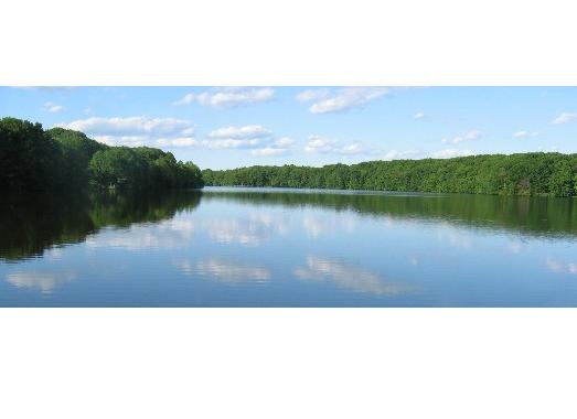
On this hilly walk around the Town of Manchester's 60 acre pond, hikers can see wildflowers, water birds and a
historic paper mill.
The Pond and hiking trail are hidden from nearby highways and local roads. It is surrounded mostly by mature forest
on the east, a few apartments, and some scattered homes. There is also quiet Union Pond Park with a braille trail, a dock
on the south, and a skating pond in winter; and the large Northwest Park with an observation deck, 2 baseball fields,
garden, and picnic pavilion on the west side.
Union Pond hosts a large number of water birds -- Canada geese, sea gulls, mallards, cormorants, and other birds year
round. More infrequent visitors include osprey, great blue heron, great egret, and passing Bald Eagles looking for open
water in winter.
In the diagram below, click on the "Boat Launch" icon ![]() to jump to
the Town of Manchester's "Canoe & Kayak Access Guide" page, for information on this launch site.
to jump to
the Town of Manchester's "Canoe & Kayak Access Guide" page, for information on this launch site.
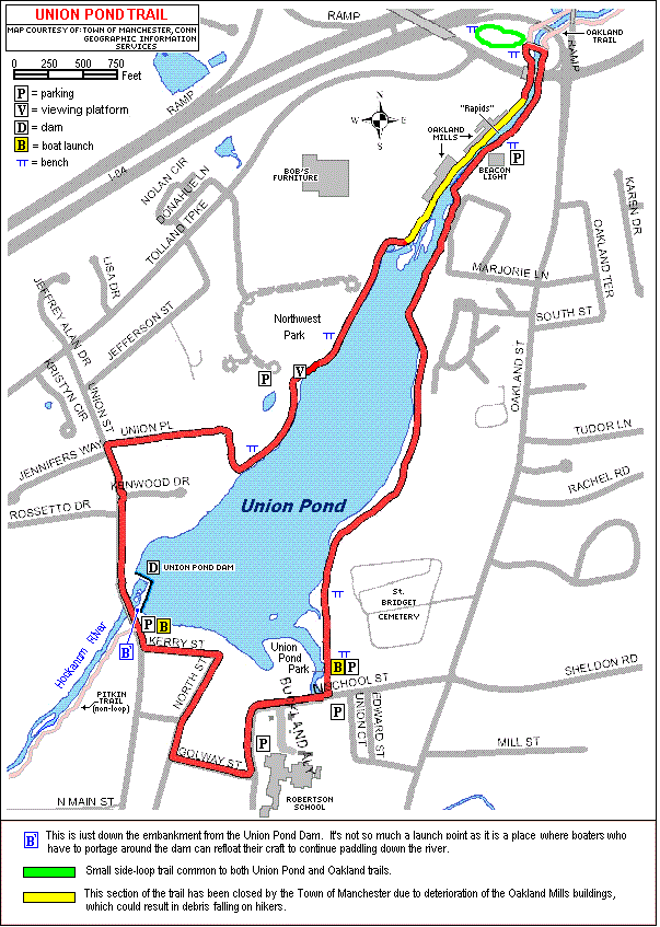
The trailhead officially starts at the boat launch site, crosses the grass on the right side of the Pond, and enters
the woods ahead. The path is an old dirt road for a while, with great Pond views for almost a mile on the left; and the
Saint Bridget Cemetery, for a short span, back through the trees on the right.
The path then climbs a hill, and there is a side trail off to the right that goes out to Garden Sales greenhouses
and perennial gardens in season. Back up the hill the trail continues along the woodland crest and past moss-covered
mounds that are the only reminders of the destructive tornado that crossed over the Pond and through the forest here in
1971, leaving hundreds of fallen trees.
Proceeding further upstream the trail crosses the lawn behind the Oakland Heights Apartments, goes down a wooded hill,
passes close to the Pond, and moves past a majestic old White Pine tree. It then wanders along the shoreline past mature
Highbush Blueberry bushes around the edge of the water; and then past the Forest Pond Condominiums and over their scenic
footbridge, built by us in 2003. There is a small patch of rare Trailing Arbutus ground cover here, and abundant Mountain
Laurel bushes hanging over the waterway. The prominent boulders were probably rolled here out of early farm fields up
the hill.
Next the trail passes behind the Beacon Light and Supply Company, among numerous large White Pines planted by us as
seedlings many years ago. As the path continues upstream the quiet pond waters are interrupted by the rushing river
entering the pond.
Note: This section of the Hockanum is known as the Rapids; and is most challenging to kayakers and canoeists,
descending as it does over a series of sandstone ledges during the Class-II swift water of the annual River Race.
The open slope on the right, off Oakland Street, is the best spectator area for watching the racers go by.
Note: For information on the River Race, click here or access "Canoe/Kayak" off
the HRLPC Home Page above.
Following the trail further up the river past more rapids, footing is more difficult with rough ledge underfoot all
the way under the Tolland Turnpike vehicle bridge. Then the path turns to the right, and up a short climb to reach a
footbridge which crosses the river.
Please Note: Beginning on or about September 12, 2016, and probably through
the end of September, work will be done on I-84 Exit-63 here. During this period, this trail will likely be
closed, at least in this area, for safety reasons.
---------------
For those hikers wishing to keep following the Hockanum upstream and not cross the river, the
On the other hand, if the hiker does cross the river on our big footbridge and turns RIGHT, s/he will continue
along the Oakland Trail along the opposite shore.
---------------
If the hiker does cross the river the Union Pond Trail goes over the bridge and turns LEFT, to continue back
down the west side of the river. All the beautiful White Pines on the west side of the footbridge were planted by the
Linear Park Committee starting in 1983. And the expansive meadow, full of wildflowers, was created when the new footbridge
replaced an old footbridge one in 2006.
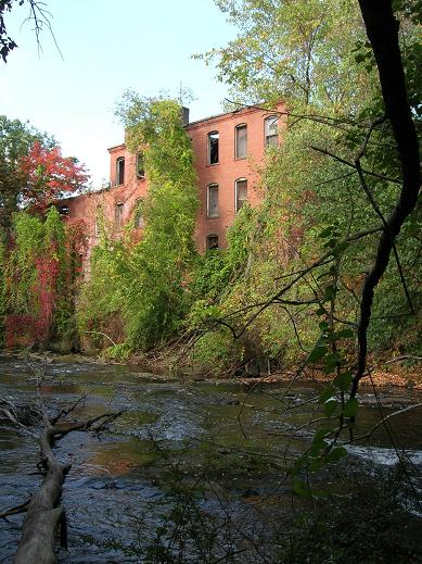
Going down the west side, the Union Pond Trail first descends a steep set of steps, proceeds along a rocky base, and
then goes up onto the old Oakland Paper Mill property, with the ancient brick walls close on the right and a slope dropping
off sharply to the river on the left. This narrow path stays close to several buidings of varying ages from the late
1700s. This complex of paper mills of sandstone and brick are remarkable, with remnants of the large metal flume still in
place in the wall; while its curved stone supports can also be seen underfoot. Without the river and its driving power,
these historic mills wouldn't have been built here. Reference the
Please note: The section of the Trail between the Oakland Mills buildings and
the River has recently been closed off by the Town of Manchester due to the deteriorating condition of the buildings, which
could rain debris on hikers at any time. Hikers are therefore urged to avoid this stretch of the
trail.
Then the trail opens out onto a flat meadow, curves around to the right, and goes through a long alley of tall pine
trees first planted by us in April, 1981. Glimpses of the Pond can be seen through the trees on the left and Northwest Park
up the slope on the right. Granite steps go up to the Park; where the path curves around to the left and back into the
woods along the water. (If you come to a chain-link fence barrier, you must turn back.) A blaze takes the trail to the
right, which then curves left and out to Union Place.
The course is now on pavement, out to Union Street, left down Union Street, and over the Hockanum on the Union Street
Bridge. There are spectacular views of the Union Pond Dam and waterfall here. Past the dam is a parking lot for the
Continuing along the Union Pond trail, you next turn left onto Kerry Street to a charming tour of the historic Union
Village. Finally, you proceed right onto North Street, left on Golway Street, and finally back to your starting point.
Canoe/Kayak: Details on the two boat launch icons can be found on the Town of Manchester
web site's
Historical Information:
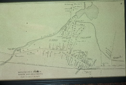
Union Pond was created by the erection of a dam just upstream from Union Street and adjacent to
the historic Union Village. This dam, built in the early 1800s, provided water power for the Pitkin Cotton Mill and later
the Union Manufacturing Company mill complex, which was situated on the riverbank just downstream from Union Street in the
North End of Manchester. The original dam was much smaller than the current one, which is the latest of several rebuidlings
which have occurred over the years.
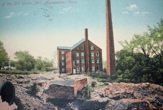
Oakland Mills. An early sawmill and gristmill made use of the water power at "Oakland." In 1784, Butler and
Hudson established a paper mill, which operated on and off under various owners until 1864, when the Cheney Brothers took
command for a few years and reorganized it as the Hudson-Cheney Paper Company, making all the post card paper for the U.S.
government for several years.
Through various other reorganizations, the factory "has manufactured the finest class of papers, including bank-note
paper." (History of Manchester, Connecticut, by Mathias Spiess and Percy W. Bidwell, published 1924.)
"In 1899, the American Writing Paper Company, which was formed to take over a chain of paper mills, bought the Oakland
Mill ... since that time, the mill has been practically rebuilt, wooden buildings being replaced with brick." (The
Manchester Herald, June 13, 1914.)
Like many businesses, the paper mill suffered financially during the Great Depression of the 1930s, and went out of
business in 1933. The Dexter Company bought the mills and processed pulp here in the 1940s. Other businesses have used
the buildings since then, including Raybestos, Conyers (cement mixing), and a recycling center.
By careful observation, hikers may discover clues to what was manufactured here over the many years of changes.
Pitkin Cotton Mill. A group headed by Samuel Pitkin established a cotton mill here in 1794. David Watkinson and
his brothers took over in 1819, and renamed it the Union Manufacturing Company.
In 1866. the company built the Union Dam, 20 feet thick at the base. It was the only dam in Manchester that survived
the violent flood of 1869.
Union Manufacturing, as other employers of the time, built housing for workers, which we still see in the "Old North
End." The story goes that the mills' treasurer absconded with funds in 1900, and the company closed.
Cheney Brothers bought the buildings and water rights, and built an electric generating plant in 1901 on North Main
Street next to the river. Huge metal pipes brought water from Union Pond to the power-generating plant. The North Main
Street section of the Hockanum is the site of the Ledyard and Watson paper mill, which furnished paper to The Hartford
Courant on which the report of the Lexington and Concord battles was printed in 1775. Union Village was designated a
National Historic District in August, 2002.
An excellent article on the Union Village Historic District, within which Union Pond itself is a key item,
can be found by clicking
here.
Look for the "Historical Background and Significance" heading about a third of the way into the page.
Following are historical images of the Union Pond complex. Click on any image to see a larger version of it.
|
|
|---|
Following are a couple of photos taken along the trail. Click on any image to see a larger version of it.
|
|
|---|