
| HRLPC Home | Distance | Maintained By | Parking | Trail Walk | Canoe/Kayak |
|---|---|---|---|---|---|
| Historical Info | Trail Restrictions | Blaze Markings | Trail Benches | Trail Photos |
Maintained by: The Hockanum River Linear Park Committee (HRLPC)
Parking at the beginning of the trail:
Parking is on the far left side of the Adams Mill Restaurant, 165 Adams Street, this being on the north side of
the river and up a small incline. The trail begins with a short hike up the side of a dike, where you go left across a
historic watergate on a footbridge.
The trail walk:
(Note that the HRLPC favors locating the trail as close to the river as possible when laying out and clearing trails.)
Across the footbridge, the trail proceeds back along the top of the old earthen dike and curves around to the right.
Once past the curve you'll find a side-fork which bears left, while the main right fork goes behind several modern
industrial buildings, continuing straight towards the river. (The earthen dike you're walking along contained the 30-acre
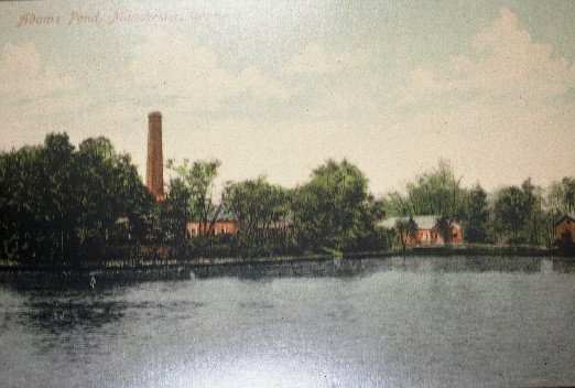
Adams Pond for the mill's water power.)
Near the end of the dike the path goes down a flight of steps on the left, with the river ahead. At the bottom, a
short side trip to the right, down the river, gives the hiker a view of the old sandstone dam ruins and the frame of the
brick hydroelectric structure built by the E.E.Hilliard Company around 1907. This dam burst during the great New England
Hurricane of 1938.
Returning to the main river trail, it goes upstream along the river, always following orange blazes, and past a
wooden bench. Nearby is a side trail, back into the woods, to an earlier dam with some modern-day carvings. The date
here is an authentic 1867.
Back on the main trail going up along the river, the course climbs onto another old dike, still going upstream, then
down a few steps, still further up and close to the river, up more steps, around to the left, up a slope, around the right,
up again and along the top of a high slope. This follows past many Mountain Laurel and gives a breathtaking view of the
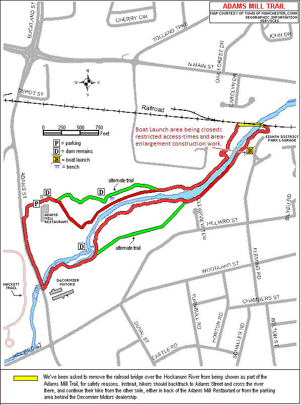
river far below. The trail then goes out to the tracks and a railroad trestle, built in 1850.
PLEASE NOTE: Hikers should not cross the railroad bridge to get to the
south side of the trail. Instead, those wishing to hike the other side should backtrack to Adams Street and cross the small
Adams Street bridge over the Hockanum River there, to get to the south side of the river, and the trail access
behind the former DeCormier Nissan dealership.
In the diagram below, click on the "Boat Launch" icon ![]() to jump to
the Town of Manchester's "Canoe & Kayak Access Guide" page, for information on this launch site.
to jump to
the Town of Manchester's "Canoe & Kayak Access Guide" page, for information on this launch site.
From the Adams Mill Restaurant, follow the sidewalk down Adams Street to the south and across the Vehicular
Bridge over the Hockanum River and immediately turn left and follow the trail, on the south side, close
to the river, on lawn and woodland next to the now vacant DeCormier Motors property. Be sure to admire the
very large Sycamore tree on the river bank, then follow the very curving waterway upstream, noting that it
has split into two distinct channels below the old Sandstone Dam that burst in the Great Hurricane of 1938.
Follow the path further upstream around to the left and then to the right, on the river bank, where the remains
of the major hydroelectric dam and ruins of the brick power plant are readily visible, as is another unique
Sycamore tree leaning very precariously over the river. Scattered in the river and buried in the river bank are
many of the huge blocks of sandstone from the old dam.
Proceeding further upstream, stay close to the river, then over a very short footbridge the trail makes a
sharp right turn inland, at two orange blazes, through a beautiful forest of trees all started after the loss
of the dam in 1938. There is a prominent row of big Black Birch trees along the river here. The trail curves
upstream and very soon becomes a little hazardous as it climbs a sandstone ledge up a ramp and steps for greater
views of the river. Much recent trail reconstruction work is visible here with lots of new edge boards and
U-posts holding the trail edges in place where many trees have fallen into the river from previous winter floods.
PLEASE NOTE: This reconstruction effort is ongoing, and during the winter
this area can be hazardous. We do NOT recommend traversing this construction area particularly during winter
months. We anticipate stabilizing the area during the spring/summer of 2014, after which we'll remove this
precautionary warning. Then the trail comes out onto a nice flat grassy slope onto the Eighth Utilities
District property, where a new footbridge is planned to cross the river to connect the two sides of the Adams
Mill trail system. The Railroad Trestle, high above ahead, is where the current trail ends.
The return course, now downstream, follows the same route close to the river, and then where it flattens out,
off the sandstone ledge, the interesting alternate path is flat and wide, to the left along the Sewer Right of
Way, curving through beautiful mature forest and meadow and out to the rear of DeCormier Motors and back out to
Adams Street and north to the Adams Mill Restaurant starting point.
The hungry hiker will invariably stop in for a delighful lunch and ask to say hello to Tony Scarpace, the
owner, who has graciously allowed us to park, hike and maintain our trail there. There are various historic
framed prints hanging in the restaurant.
Canoe/Kayak:
Details on the boat launch icon can be found on the Town of Manchester web site's
Historical Information:
In the 19th century, before back-hoes and Caterpillar tractors, numerous dikes and dams were built along the
Hockanum River to harness water power for mill machinery. This hike shows remains of dams, ponds and sluiceways
from long ago. Except for the Union Pond Dam, all of the dams along the Hockanum were destroyed in a devastating
flood of 1869.
In 1863, Peter C. Adams had purchased a paper mill, outbuildings, 38 acres of land and Hockanum River water privileges.
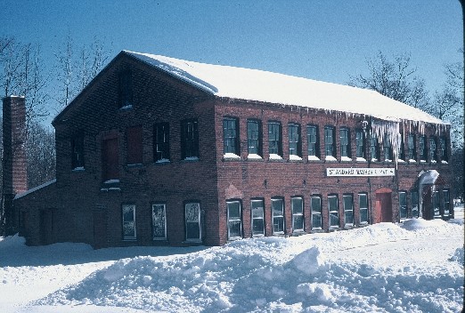
He purchased additional land, houses and barns between 1869 and 1876. The present Adams Mill Restaurant building was
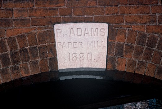
constructed in 1880 (see the marble inscription over the front door). The Adams Mill flourished until Peter Adams' death
in 1896.
Financial decline and failure closed most mills by the 1880s and 1890s, leaving a few mill buildings and many ruins. The
old Hilliard Mills and the Adams Mill are among the best preserved along the Hockanum River. (See also the Oakland Mills
along the
Behind the Adams Mill Restaurant can be seen ruins of the extensive system of dikes and two dams which were destroyed
in the 1938 hurricane.
The former Adams Mill became the Standard Washer and Mat, which was purchased in 1982 by Brad Morton and Tony Scarpace,
who painstakingly renovated it to the present Adams Mill Restaurant. The HRLPC is proud to witness the present restoration
of this historic mill to a viable modern-day use. For information on the restaurant, click:
Additional Historical Items:
Along the Adams Mill trail there are numerous historic structures which the observant hiker may see. For
example, at the upper end of the trail are a sandstone headwall, several old earthen dikes, and the remains of 2
sandstone dams.
And of course the existing restaurant, which dates from 1880. The original keystone with the date on it is on the east
end of the restaurant in an archway (the keystone with date over the front door is a replica). The smaller brick building
on the north side, to the left of the trail entrance, is historic as well.
Of more recent note, in October, 2011, severe erosion washed out portions of the Trail, necessitating closure of that
portion of the trail. Beginning in the summer of 2013 and extending into early 2014, reconstruction efforts were done. An
article in the Hartford Courant in February, 2014, by Peter Marteka documented the rebuild's progress. The article can be
accessed by clicking
Also, a slideshow of the progress up to about that point can be found in the "Slide-Shows" link off the
HRWA Home page. The slideshow can be directly accessed by clicking
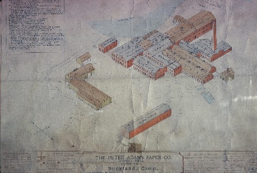
Following are images, maps and drawings of the Adams Mill complex. Click on each image to bring up a
larger version of it.