| Hockanum River Linear Park Committee founder Dr. Douglas H. Smith passed away on March
28, 2017.
To read Doug's obituary, from the April 9, 2017 Hartford Courant, please click obituary. |
|---|
| On June 1, 2018, Bryan Island was formally renamed to "Doug Smith Island", in a ceremony
on the
island. To access a section on the dedication ceremony in this website, please click ceremony. |
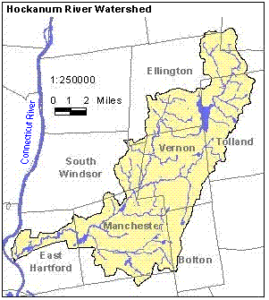
The Hockanum River Watershed* encompasses 9 towns and 77 square miles in north central Connecticut. The watershed
consists of several sub-watersheds, including Charters Brook, Marsh Brook, the Tankerhoosen River, Shenipsit Lake, Lydall
Brook, Bigelow Brook and Hop Brook. These sub-watersheds drain into the Hockanum River, which joins the
Connecticut River and eventually empties into Long Island Sound.
The Hockanum River Watershed Association was organized in December, 1996, and consists of a volunteer group with
members from the 4 towns in the Hockanum River Watershed which the river physically passes through. This group is
dedicated to the preservation and protection of the watershed area's green belt and water quality.
Hockanum River Linear Park Committees are active in all of the 4 towns along the river, and these groups work to keep
the river and woodlands clean; to maintain the hiking trails along the river; and to promote activities such as kayaking
and canoeing, jogging, cross-country skiing, snow shoeing, bird watching and photography, both on and along the river and
its tributaries.
Contact Us
For information or questions concerning the Hockanum River Watershed Association and its activities, or on making
donations to either the HRWA or any of its towns' committees, please check the "Contact Us" link on any of the
pages of the Town you're interested in.
______________________
*The word HOCKANUM comes from the Native American word "Hocquaun", meaning a hook-shaped
or crooked river.
A watershed includes the land area that drains rain water or snowmelt into a river, river system
or body of water.
Web contact: jamesh52@comcast.net